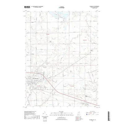
2019 Map of Columbia City
USGS Topo · Published 2019About this map
The Eel River and Blue River converge near the heart of Whitley County, Indiana, defining the drainage patterns of this agricultural landscape. Columbia City serves as the central hub, surrounded by a network of smaller communities including Collins, Coesse, and Cresco. The map records several small airfields like Terrys Airport and Wigent Airport, reflecting a local aviation history alongside traditional farming. North of the city, a chain of glacial lakes—Shriner Lake, Round Lake, and Little Cedar Lake—breaks the rectilinear grid of county roads. For genealogists, the map preserves the locations of several burial grounds, including Garrison Cem, South Park Cem, and Nolt Cem, while an extensive system of drainage ditches like Krider Ditch and Mowrey Ditch illustrates the long-term engineering of the local hydrology.
Find a feature on this map
105 named features on this map. Tap any name to fly to it.
Don’t see what you’re looking for? This feature index may not catch every label — zoom into the map to look around manually.
Map Details
Editions of this 2019 Columbia City Map
This is the sole edition of this map. No revisions or reprints were ever made.
Other maps of this area

1951 · Ormas
USGS Topo · 1:24,000

1951 · Merriam
USGS Topo · 1:24,000

1953 · Fort Wayne
USGS Topo · 1:250,000

1955 · Columbia City
USGS Topo · 1:24,000

1955 · Ege
USGS Topo · 1:24,000

1956 · Fort Wayne
USGS Topo · 1:250,000

1956 · Lorane
USGS Topo · 1:24,000

1957 · Churubusco
USGS Topo · 1:24,000

1961 · Arcola
USGS Topo · 1:24,000
1961 · Laud
USGS Topo · 1:24,000