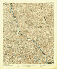
1904 Map of Columbia
USGS Topo · Published 1937About this map
Broad River dominates the central axis of this landscape, serving as a corridor of transit and trade that defined the early twentieth-century boundaries of Newberry Co, Fairfield Co, and Richland Co. Before modern bridging became commonplace, a network of river crossings supported the local economy, including Shelton Ferry, Wise Ferry, and Lorick Ferry. The map reveals a transition from these water-based connections to the rising influence of steel, with the Southern Railway and the Columbia Newberry And Laurens Railroad cutting through the terrain.
Find a feature on this map
123 named features on this map. Tap any name to fly to it.
Don’t see what you’re looking for? This feature index may not catch every label — zoom into the map to look around manually.
Map Details
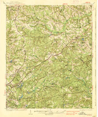
Editions of this 1904 Columbia Map
2 editions found
Other maps of this area

1904 · Columbia
USGS Topo · 1:125,000

1935 · Killian
USGS Topo · 1:48,000
1937 · Killian
USGS Topo · 1:62,500

1941 · Spartanburg
USGS Topo · 1:250,000

1942 · Camden
USGS Topo · 1:125,000
1944 · Gilbert
USGS Topo · 1:62,500

1944 · Edmund
USGS Topo · 1:62,500
1946 · Irmo
USGS Topo · 1:24,000

1947 · Columbia North
USGS Topo · 1:24,000

1947 · Richtex
USGS Topo · 1:24,000