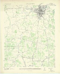
1936 Map of Columbia
USGS Topo · Published 1936About this map
The city of Columbia serves as a thriving regional hub along the Duck River in the mid-1930s, defined by its intersection of rail and river commerce. This Tennessee Valley Authority survey captures the transition from the dense urban grid of Riverside to the surrounding agricultural landscape of Maury County. Notable institutional presence includes the Columbia Mil Academy and the State Agricultural Experiment Sta, signaling the area's importance to both education and Southern agriculture.
Find a feature on this map
54 named features on this map. Tap any name to fly to it.
Don’t see what you’re looking for? This feature index may not catch every label — zoom into the map to look around manually.
Map Details
Editions of this 1936 Columbia Map
2 editions found
Other maps of this area

1901 · Colombia
USGS Topo · 1:125,000

1936 · Godwin
USGS Topo · 1:24,000

1936 · Sandy Hook
USGS Topo · 1:24,000

1936 · Williamsport
USGS Topo · 1:24,000

1936 · Campbells Station
USGS Topo · 1:24,000

1936 · Carters Creek
USGS Topo · 1:24,000

1936 · Mount Pleasant
USGS Topo · 1:24,000

1936 · Glendale
USGS Topo · 1:24,000

1936 · Columbia
USGS Topo · 1:24,000

1936 · Lynnville
USGS Topo · 1:24,000