
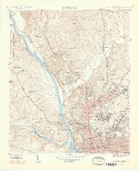
1948 Map of Columbia North
USGS Topo · Published 1948About this map
The Congaree River forms at the confluence of the Broad River and Saluda River, anchoring a landscape of significant institutional development in the late 1940s. The state capital's footprint is defined by a high concentration of public works and social infrastructure, including the State Capitol, the State Penitentiary, and the S C Womens Penitentiary. Beyond the government core, the map reveals a network of residential and educational growth in neighborhoods like Eau Claire, Arden, and Waverly. The inclusion of the Soldiers Home, Epworth Orphanage, and Waverly Sanitarium reflects the era's specialized social services. To the north, the terrain transitions into the Harbison State Forest and the rolling hills of the Crane Creek watershed, where smaller rural settlements like Brice Hill and Munster remain distinct from the expanding city center.
Find a feature on this map
103 named features on this map. Tap any name to fly to it.
Don’t see what you’re looking for? This feature index may not catch every label — zoom into the map to look around manually.
Map Details
Editions of this 1948 Columbia North Map
2 editions found
Other maps of this area

1904 · Columbia
USGS Topo · 1:125,000

1935 · Killian
USGS Topo · 1:48,000

1937 · Killian
USGS Topo · 1:62,500

1941 · Spartanburg
USGS Topo · 1:250,000

1942 · Camden
USGS Topo · 1:125,000

1944 · Edmund
USGS Topo · 1:62,500

1946 · Irmo
USGS Topo · 1:24,000

1947 · Columbia North
USGS Topo · 1:24,000

1947 · Richtex
USGS Topo · 1:24,000

1948 · Hopkins
USGS Topo · 1:62,500