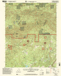
2001 Map of Columbia SE
USGS Topo · Published 2004About this map
The Stanislaus National Forest dominates the northern reaches of this landscape, where steep canyons are carved by Stony Gulch and Knight Creek. This area of Tuolumne County reflects a long history of resource extraction, evidenced by a dense concentration of mining sites such as the Indian Girl Mine, Star Mine, and the Lucky Strike Mine. The rugged topography is defined by prominent elevations like Eagle Ridge and Telegraph Hill, while the Phoenix Powerhouse and Phoenix Reservoir at the southern edge indicate the importance of water management and power generation in this mountain terrain.
Find a feature on this map
58 named features on this map. Tap any name to fly to it.
Don’t see what you’re looking for? This feature index may not catch every label — zoom into the map to look around manually.
Map Details
Editions of this 2001 Columbia SE Map
This is the sole edition of this map. No revisions or reprints were ever made.
Other maps of this area

1891 · Big Trees
USGS Topo · 1:125,000

1893 · Sonora
USGS Topo · 1:125,000

1894 · Big Trees
USGS Topo · 1:125,000

1896 · Sonora
USGS Topo · 1:125,000

1897 · Sonora
USGS Topo · 1:125,000

1897 · Big Trees
USGS Topo · 1:125,000

1898 · Sonora
USGS Topo · 1:125,000

1901 · Big Trees
USGS Topo · 1:125,000

1947 · Sacramento
USGS Topo · 1:250,000

1947 · San Jose
USGS Topo · 1:250,000