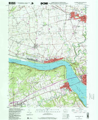
1997 Map of Columbia West
USGS Topo · Published 1999About this map
The Susquehanna River carves a deep path through this landscape, dividing the riverfront communities of Marietta and Columbia from the elevated terrain of the Hellam Hills to the west. This late-twentieth-century study shows the established rail infrastructure of Conrail following the riverbanks, connecting industrial points like the Compressor Sta and various riverside quarries. The map captures the distinct character of the Lancaster and York County border, where the relatively flat agricultural lands of East Donegal and West Donegal meet the prominent overlooks at Chickies Rock and Buzzards Roost.
Find a feature on this map
67 named features on this map. Tap any name to fly to it.
Don’t see what you’re looking for? This feature index may not catch every label — zoom into the map to look around manually.
Map Details
Editions of this 1997 Columbia West Map
This is the sole edition of this map. No revisions or reprints were ever made.
Other maps of this area

1902 · Lancaster
USGS Topo · 1:62,500

1904 · Lancaster
USGS Topo · 1:62,500

1908 · Middletown
USGS Topo · 1:62,500

1908 · York
USGS Topo · 1:62,500

1910 · York
USGS Topo · 1:62,500

1912 · Mc Calls Ferry
USGS Topo · 1:62,500

1943 · Lancaster
USGS Topo · 1:62,500

1943 · Middletown
USGS Topo · 1:62,500

1943 · Mc Calls Ferry
USGS Topo · 1:62,500

1948 · Baltimore
USGS Topo · 1:250,000