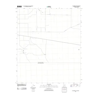
2010 Map of Columbus SE
USGS Topo · Published 2010About this map
The international border between the United States of America and Estados Unidos Mexicanos defines the southern extent of this 2010 topographic record. This arid landscape in Luna County is marked by functional water infrastructure essential for ranching and survival, including the Stiles Reservoir and isolated landmarks like the Little Windmill and O'Bryan Windmill. Drainage is channeled through the north-reaching Seventysix Draw, while the topographic relief is dominated by Black Hill in the west. A network of rural routes such as Dustdevil Rd and County Rd-8006 provides access across the desert floor, illustrating the sparse but organized settlement pattern near the Mexican border at the start of the twenty-first century.
Find a feature on this map
11 named features on this map. Tap any name to fly to it.
Don’t see what you’re looking for? This feature index may not catch every label — zoom into the map to look around manually.
Map Details
Editions of this 2010 Columbus SE Map
This is the sole edition of this map. No revisions or reprints were ever made.
Other maps of this area

1917 · Camel Mountain
USGS Topo · 1:62,500

1917 · Columbus
USGS Topo · 1:62,500

1918 · Columbus
USGS Topo · 1:62,500

1920 · Columbus
USGS Topo · 1:62,500

1953 · El Paso
USGS Topo · 1:250,000

1959 · El Paso
USGS Topo · 1:250,000

1964 · El Paso
USGS Topo · 1:250,000

1965 · El Paso
USGS Topo · 1:250,000
1965 · North Peak
USGS Topo · 1:24,000
1965 · Columbus
USGS Topo · 1:24,000