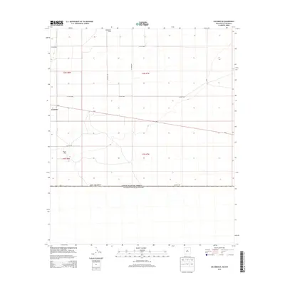
2013 Map of Columbus SE
USGS Topo · Published 2013About this map
Columbus anchors the western edge of this High Desert landscape, situated just north of the international border where the New Mexico and Estados Unidos Mexicanos boundary line cuts a straight path through the basin. The terrain is marked by the drainage of Seventysix Draw in the north and the distinct rise of Black Hill in the southwest. Transportation in this borderland area is defined by Nm-9, which runs east-west across the quadrangle, and a network of rural routes including Dustdevil Rd and Black Hill Rd. This survey captures the sparse settlement patterns and ranching infrastructure typical of the Chihuahuan Desert before further 21st-century developments, showing a landscape defined more by its township lines and survey markers than dense population.
Find a feature on this map
16 named features on this map. Tap any name to fly to it.
Don’t see what you’re looking for? This feature index may not catch every label — zoom into the map to look around manually.
Map Details
Editions of this 2013 Columbus SE Map
This is the sole edition of this map. No revisions or reprints were ever made.
Other maps of this area

1917 · Camel Mountain
USGS Topo · 1:62,500

1917 · Columbus
USGS Topo · 1:62,500

1918 · Columbus
USGS Topo · 1:62,500

1920 · Columbus
USGS Topo · 1:62,500

1953 · El Paso
USGS Topo · 1:250,000

1959 · El Paso
USGS Topo · 1:250,000

1964 · El Paso
USGS Topo · 1:250,000

1965 · El Paso
USGS Topo · 1:250,000
1965 · North Peak
USGS Topo · 1:24,000
1965 · Columbus
USGS Topo · 1:24,000