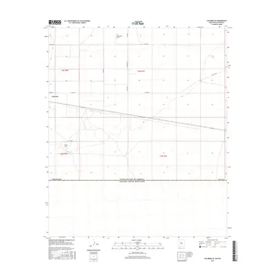
2017 Map of Columbus SE
USGS Topo · Published 2017About this map
The southern edge of Columbus sits at the precipice of the international border in this 2017 survey of the high desert in Luna County. The landscape is defined by the stark demarcation of the border with Estados Unidos Mexicanos, where the grid of American county roads abruptly meets the northern stretches of Chihuahua. Desert hydrology is represented by ephemeral features such as Seventysix Draw and the Stiles Reservoir, while the prominent volcanic landform of Black Hill rises above the basin floor. Local transit is managed through a network of rural routes including Whirlwind Rd, Pol Ranch Rd, and the tellingly named Boundry St, which runs directly along the town's southern limits.
Find a feature on this map
20 named features on this map. Tap any name to fly to it.
Don’t see what you’re looking for? This feature index may not catch every label — zoom into the map to look around manually.
Map Details
Editions of this 2017 Columbus SE Map
This is the sole edition of this map. No revisions or reprints were ever made.
Other maps of this area

1917 · Camel Mountain
USGS Topo · 1:62,500

1917 · Columbus
USGS Topo · 1:62,500

1918 · Columbus
USGS Topo · 1:62,500

1920 · Columbus
USGS Topo · 1:62,500

1953 · El Paso
USGS Topo · 1:250,000

1959 · El Paso
USGS Topo · 1:250,000

1964 · El Paso
USGS Topo · 1:250,000

1965 · El Paso
USGS Topo · 1:250,000
1965 · North Peak
USGS Topo · 1:24,000
1965 · Columbus
USGS Topo · 1:24,000