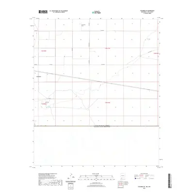
2020 Map of Columbus SE
USGS Topo · Published 2020About this map
The southern edge of Columbus marks a landscape defined by its proximity to the international border, where the United States of America Estados Unidos Mexicanos boundary line cuts across the desert floor. This 2020 survey reveals a sparse grid of ranch roads and township boundaries, including t28s r8w and t29s r7w, that organize the arid terrain. To the west, the elevation rises slightly at Black Hill, while the nearby Stiles Reservoir and the ephemeral Seventysix Draw indicate the critical role of water management in this high-desert environment. The road network, featuring local tracks like Whirlwind Rd and Pol Ranch Rd, illustrates how modern infrastructure still follows the fundamental section lines of the original Public Land Survey System. This map serves as a contemporary record of the land use and geographical markers just north of the Mexican border.
Find a feature on this map
21 named features on this map. Tap any name to fly to it.
Don’t see what you’re looking for? This feature index may not catch every label — zoom into the map to look around manually.
Map Details
Editions of this 2020 Columbus SE Map
This is the sole edition of this map. No revisions or reprints were ever made.
Other maps of this area

1917 · Camel Mountain
USGS Topo · 1:62,500

1917 · Columbus
USGS Topo · 1:62,500

1918 · Columbus
USGS Topo · 1:62,500

1920 · Columbus
USGS Topo · 1:62,500

1953 · El Paso
USGS Topo · 1:250,000

1959 · El Paso
USGS Topo · 1:250,000

1964 · El Paso
USGS Topo · 1:250,000

1965 · El Paso
USGS Topo · 1:250,000
1965 · North Peak
USGS Topo · 1:24,000
1965 · Columbus
USGS Topo · 1:24,000