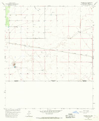
1966 Map of Columbus SE
USGS Topo · Published 1967About this map
The international border between the United States and Mexico defines the southern reach of this arid borderland survey from the mid-1960s. The landscape is characterized by its vital water infrastructure, tracing the survival of ranching operations through scattered resources like Dean Well, O'Bryan Windmill, and the Little Windmill. Arid drainage patterns are marked by the Seventysix Draw, which cuts across the northern sections towards more level terrain.
Find a feature on this map
17 named features on this map. Tap any name to fly to it.
Don’t see what you’re looking for? This feature index may not catch every label — zoom into the map to look around manually.
Map Details
Editions of this 1966 Columbus SE Map
This is the sole edition of this map. No revisions or reprints were ever made.
Other maps of this area

1917 · Camel Mountain
USGS Topo · 1:62,500

1917 · Columbus
USGS Topo · 1:62,500

1918 · Columbus
USGS Topo · 1:62,500

1920 · Columbus
USGS Topo · 1:62,500

1953 · El Paso
USGS Topo · 1:250,000

1959 · El Paso
USGS Topo · 1:250,000

1964 · El Paso
USGS Topo · 1:250,000

1965 · El Paso
USGS Topo · 1:250,000
1965 · North Peak
USGS Topo · 1:24,000
1965 · Columbus
USGS Topo · 1:24,000