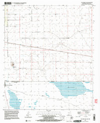
1996 Map of Columbus SE
USGS Topo · Published 2003About this map
Puerto Palomas and Columbus sit along the international border in this mid-1990s survey of the high desert between New Mexico and Chihuahua. The landscape is defined by the rigid grid of the public land survey system meeting the open basins and plateaus of Mexico, including the broad Llano Los Acebuches. Human activity is primarily centered on the transit through the border and the extraction of water in an arid environment, evidenced by scattered points like Dean Well, Stiles Reservoir, and the O'Bryan Windmill. North of the boundary, a corporate boundary and Gravel Pits indicate local industry, while south of the line, settlements like Nuevo Horizonte and La Brecha are established near natural landmarks like Tres Ojos and the Ruinas Indias. The presence of a Canal and various tanks underscores the critical importance of water management for these borderland communities.
Find a feature on this map
24 named features on this map. Tap any name to fly to it.
Don’t see what you’re looking for? This feature index may not catch every label — zoom into the map to look around manually.
Map Details
Editions of this 1996 Columbus SE Map
This is the sole edition of this map. No revisions or reprints were ever made.
Other maps of this area

1917 · Camel Mountain
USGS Topo · 1:62,500

1917 · Columbus
USGS Topo · 1:62,500

1918 · Columbus
USGS Topo · 1:62,500

1920 · Columbus
USGS Topo · 1:62,500

1953 · El Paso
USGS Topo · 1:250,000

1959 · El Paso
USGS Topo · 1:250,000

1964 · El Paso
USGS Topo · 1:250,000

1965 · El Paso
USGS Topo · 1:250,000
1965 · North Peak
USGS Topo · 1:24,000
1965 · Columbus
USGS Topo · 1:24,000