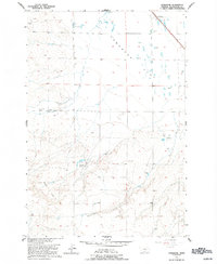
1956 Map of Comanche
USGS Topo · Published 1993About this map
Comanche sits at the northern edge of this mid-century survey, a central point for the surrounding agricultural community. The landscape is defined by the broad Comanche Flat, where ranching operations such as Heiken Ranch, Ballard Ranch, and Schroder Ranch are established across the terrain. These family-named holdings highlight the settlement patterns of the Missouri River Basin development era, supported by local infrastructure like the rural Sch and the Comanche Cem.
Find a feature on this map
16 named features on this map. Tap any name to fly to it.
Don’t see what you’re looking for? This feature index may not catch every label — zoom into the map to look around manually.
Map Details
Editions of this 1956 Comanche Map
2 editions found
Other maps of this area

1954 · Billings
USGS Topo · 1:250,000

1954 · Roundup
USGS Topo · 1:250,000

1956 · Comanche
USGS Topo · 1:24,000

1956 · Acton
USGS Topo · 1:24,000

1956 · Molt
USGS Topo · 1:24,000

1956 · Rock Spring
USGS Topo · 1:24,000

1956 · Rimrock
USGS Topo · 1:24,000

1956 · Two Pine School
USGS Topo · 1:24,000

1957 · Billings
USGS Topo · 1:250,000

1958 · Billings
USGS Topo · 1:250,000