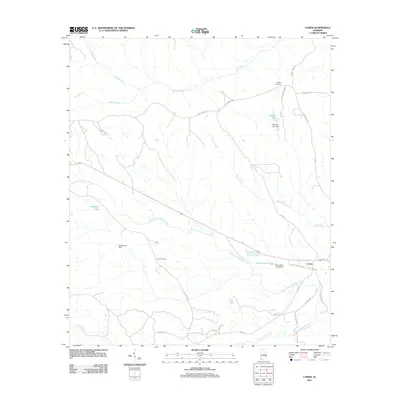
2011 Map of Comer
USGS Topo · Published 2011About this map
The small community of Comer sits at the intersection of local plantation roads and larger county arteries in this rural pocket of Barbour County. The landscape is heavily defined by its water management, featuring numerous named impoundments including McCains Lake, McCalls Pond, and Grants Duck Pond. These bodies of water, many held by structures like the Grants Duck Pond Dam and Mc Calls Lake Dam, feed into a network of waterways led by the South Fork Cowikee Creek and Bear Creek. For genealogists, the map preserves the locations of the Ramah Cemetery in the northeast and Seay Cemetery further south. The road network, including Pako Plantation Rd and Grant Brothers Rd, suggests a landscape historically dominated by large landholdings and timber or agricultural interests typical of southeastern Alabama.
Find a feature on this map
31 named features on this map. Tap any name to fly to it.
Don’t see what you’re looking for? This feature index may not catch every label — zoom into the map to look around manually.
Map Details
Editions of this 2011 Comer Map
This is the sole edition of this map. No revisions or reprints were ever made.
Other maps of this area

1953 · Dothan
USGS Topo · 1:250,000

1954 · Dothan
USGS Topo · 1:250,000

1955 · Dothan
USGS Topo · 1:250,000

1955 · Phenix City
USGS Topo · 1:250,000

1957 · Phenix City
USGS Topo · 1:250,000

1958 · Phenix City
USGS Topo · 1:250,000

1968 · White Oak
USGS Topo · 1:24,000

1968 · Clayton North
USGS Topo · 1:24,000

1968 · Mount Andrew
USGS Topo · 1:24,000
1973 · Batesville
USGS Topo · 1:24,000