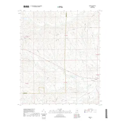
2018 Map of Comer
USGS Topo · Published 2018About this map
Comer sits as the primary settlement within this survey of the Alabama borderlands where Barbour and Bullock counties meet. The landscape is defined by the dendritic drainage patterns of S Fork Cowikee Cr and Johnson Cr, which carve through the low-lying terrain to create a series of ponds and small lakes including Grants Duck Pond, McCalls Pond, and McCains Lake. For genealogists and local historians, the inclusion of Ramah Cem and Seay Cem provides specific points of interest for family research in this rural pocket of the state.
Find a feature on this map
41 named features on this map. Tap any name to fly to it.
Don’t see what you’re looking for? This feature index may not catch every label — zoom into the map to look around manually.
Map Details
Editions of this 2018 Comer Map
This is the sole edition of this map. No revisions or reprints were ever made.
Other maps of this area

1953 · Dothan
USGS Topo · 1:250,000

1954 · Dothan
USGS Topo · 1:250,000

1955 · Dothan
USGS Topo · 1:250,000

1955 · Phenix City
USGS Topo · 1:250,000

1957 · Phenix City
USGS Topo · 1:250,000

1958 · Phenix City
USGS Topo · 1:250,000

1968 · White Oak
USGS Topo · 1:24,000

1968 · Clayton North
USGS Topo · 1:24,000

1968 · Mount Andrew
USGS Topo · 1:24,000
1973 · Batesville
USGS Topo · 1:24,000