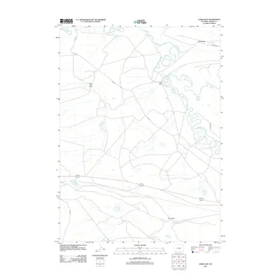
2012 Map of Como East
USGS Topo · Published 2012About this map
Oil Springs and the small settlement of Como anchor this high-plains landscape in Carbon County, where the hydrology of the Wyoming basin is on full display. The Medicine Bow River snakes across the northern portion of the sheet, joined by the winding Little Medicine Bow River and defined by distinct landforms like Calvin Bend. This arid environment is dotted with numerous small lakes and basins, including Como Lake, Punchin Lake, and Allen Lake, many of which appear as ephemeral or seasonal water bodies. The presence of Smith Reservoir and Sulphur Springs indicates the historical importance of water management and natural mineral sources in this ranching country. Transportation is marked by rural routes such as Oil Springs Rd and Fossil Rdg, which cut through the open terrain of Pine Draw and South Pine Draw.
Find a feature on this map
20 named features on this map. Tap any name to fly to it.
Don’t see what you’re looking for? This feature index may not catch every label — zoom into the map to look around manually.
Map Details
Editions of this 2012 Como East Map
This is the sole edition of this map. No revisions or reprints were ever made.
Other maps of this area

1914 · Saddleback Hills
USGS Topo · 1:62,500

1915 · Como Ridge
USGS Topo · 1:48,000

1918 · Como Ridge
USGS Topo · 1:62,500

1921 · Saddleback Hills
USGS Topo · 1:62,500

1954 · Rawlins
USGS Topo · 1:250,000

1955 · Casper
USGS Topo · 1:250,000

1958 · Rawlins
USGS Topo · 1:250,000

1958 · Casper
USGS Topo · 1:250,000

1961 · T B Ranch
USGS Topo · 1:24,000
1961 · Windy Hill
USGS Topo · 1:24,000