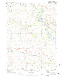
1971 Map of Como East
USGS Topo · Published 1975About this map
Carbon and Como anchor this 1971 survey of Carbon County, Wyoming, revealing a landscape defined by its extractive industry and early transport corridors. The Union Pacific railroad cuts through the southern terrain, paralleled in places by an Old Railroad Grade that speaks to the shifting infrastructure of the coal and rail era. The presence of numerous mines, prospects, and gas wells across the quadrangle underscores the region's mineral-driven economy.
Find a feature on this map
33 named features on this map. Tap any name to fly to it.
Don’t see what you’re looking for? This feature index may not catch every label — zoom into the map to look around manually.
Map Details
Editions of this 1971 Como East Map
This is the sole edition of this map. No revisions or reprints were ever made.
Other maps of this area

1914 · Saddleback Hills
USGS Topo · 1:62,500

1915 · Como Ridge
USGS Topo · 1:48,000

1918 · Como Ridge
USGS Topo · 1:62,500

1921 · Saddleback Hills
USGS Topo · 1:62,500

1954 · Rawlins
USGS Topo · 1:250,000

1955 · Casper
USGS Topo · 1:250,000

1958 · Rawlins
USGS Topo · 1:250,000

1958 · Casper
USGS Topo · 1:250,000

1961 · T B Ranch
USGS Topo · 1:24,000
1961 · Windy Hill
USGS Topo · 1:24,000