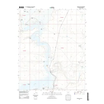
2013 Map of Conchas Dam
USGS Topo · Published 2013About this map
Conchas Dam and the expansive waters of Conchas Lake dominate this high-plains landscape in San Miguel County. The engineering of the early twentieth century is visible in the complex network of the Bell Ranch Canal and various docks serving the reservoir, such as the Conchas Aquatic Camp. The terrain is defined by dramatic mesas and canyons, including Minese Mesa and Aguilar Mesa, which tower over the Canadian River valley.
Find a feature on this map
37 named features on this map. Tap any name to fly to it.
Don’t see what you’re looking for? This feature index may not catch every label — zoom into the map to look around manually.
Map Details
Editions of this 2013 Conchas Dam Map
This is the sole edition of this map. No revisions or reprints were ever made.
Other maps of this area

1954 · Santa Fe
USGS Topo · 1:250,000

1958 · Santa Fe
USGS Topo · 1:250,000

1967 · Tenaja Mesa
USGS Topo · 1:24,000

1967 · Monument Point
USGS Topo · 1:24,000

1968 · La Cinta Mesa
USGS Topo · 1:24,000

1968 · Conchas Dam
USGS Topo · 1:24,000
1972 · Bell Ranch
USGS Topo · 1:24,000

1972 · Four V Ranch
USGS Topo · 1:24,000
1972 · Bookout Ranch
USGS Topo · 1:24,000

1972 · Wade Canyon
USGS Topo · 1:24,000