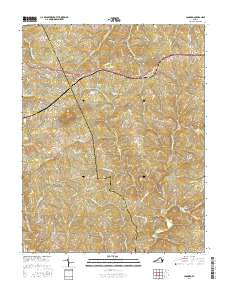
2016 Map of Concord
USGS Topo · Published 2016About this map
Concord and Spout Spring anchor the northern reaches of this landscape, situated along a busy transit corridor at the border of Appomattox Co and Campbell Co. The settlement of Sherwill marks the southern interior, where the terrain transitions from residential clusters to a network of creeks and small drainages. Water defines the local geography, featuring several named bodies such as Concord Lake, Phoebe Lake, and Townwanda Lake, while Pilot Mtn provides a clear topographic landmark. Genealogists and local historians can find the Concord Cem and trace numerous family-named roads and lanes like Thomas Farm Ln and Snapps Mill Rd. The map reveals a community defined by its waterways, including the Falling River and S Fork Falling River, which cut through the undulating hills of central Virginia.
Find a feature on this map
99 named features on this map. Tap any name to fly to it.
Don’t see what you’re looking for? This feature index may not catch every label — zoom into the map to look around manually.
Map Details
Editions of this 2016 Concord Map
This is the sole edition of this map. No revisions or reprints were ever made.
Other maps of this area

1892 · Lynchburg
USGS Topo · 1:125,000

1892 · Appomattox
USGS Topo · 1:125,000

1944 · Lynchburg
USGS Topo · 1:62,500

1947 · Roanoke
USGS Topo · 1:250,000

1950 · Lynchburg
USGS Topo · 1:62,500

1956 · Brookneal
USGS Topo · 1:62,500

1956 · Gladys
USGS Topo · 1:62,500

1958 · Appomattox
USGS Topo · 1:62,500

1959 · Roanoke
USGS Topo · 1:250,000

1963 · Roanoke
USGS Topo · 1:250,000