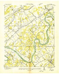
1936 Map of Concord
USGS Topo · Published 1936About this map
Concord and Friendsville anchor this 1936 survey of the river valleys where Knox, Loudon, and Blount counties meet. The landscape is defined by the winding course of the Tennessee River and the Little Tennessee River, flowing past numerous named landforms like Bussell Island, Cane Island, and Tolbert Bend. Before the mid-century hydroelectric projects transformed these waterways, the area supported a dense network of rural infrastructure, including the Southern Railway Company corridor and numerous community centers like Muddy Creek Ch and Martel Sch.
Find a feature on this map
72 named features on this map. Tap any name to fly to it.
Don’t see what you’re looking for? This feature index may not catch every label — zoom into the map to look around manually.
Map Details
Editions of this 1936 Concord Map
This is the sole edition of this map. No revisions or reprints were ever made.
Other maps of this area

1895 · Loudon
USGS Topo · 1:125,000

1935 · Binfield
USGS Topo · 1:24,000

1935 · Meadow
USGS Topo · 1:24,000

1935 · Lenoir City
USGS Topo · 1:24,000

1935 · Bethel Valley
USGS Topo · 1:24,000

1935 · Bearden
USGS Topo · 1:24,000

1935 · Lovell
USGS Topo · 1:24,000

1936 · Louisville
USGS Topo · 1:24,000

1936 · Friendship
USGS Topo · 1:48,000

1936 · Loudon
USGS Topo · 1:24,000