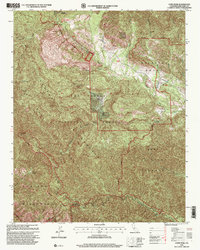
1995 Map of Cone Peak
USGS Topo · Published 2000About this map
Santa Lucia Range topography dominates this mid-1990s revision, which details the complex interface between federal lands and historic private holdings. High points like Cone Peak are home to a Cone Peak Lookout, providing oversight of the massive Ventana Wilderness and Los Padres National Forest. The map captures the specialized land use in the region, from the military presence at Fort Hunter Liggett to the enduring legacy of Spanish-era land divisions in the Milpitas Grant.
Find a feature on this map
23 named features on this map. Tap any name to fly to it.
Don’t see what you’re looking for? This feature index may not catch every label — zoom into the map to look around manually.
Map Details
Editions of this 1995 Cone Peak Map
This is the sole edition of this map. No revisions or reprints were ever made.
Other maps of this area

1919 · Junipero Serra
USGS Topo · 1:62,500

1921 · Cape San Martin
USGS Topo · 1:62,500

1921 · Lucia
USGS Topo · 1:62,500

1941 · Cape San Martin
USGS Topo · 1:62,500

1941 · Lucia
USGS Topo · 1:62,500

1941 · Junipero Serra
USGS Topo · 1:62,500

1942 · Cape San Martin
USGS Topo · 1:62,500

1947 · Lucia
USGS Topo · 1:62,500

1947 · San Luis Obispo
USGS Topo · 1:250,000

1948 · Santa Cruz
USGS Topo · 1:250,000