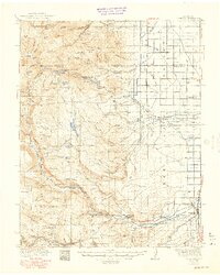
1922 Map of Conejos
USGS Topo · Published 1949About this map
The eastern expanse of the San Luis Valley meets the high elevations of the Rio Grande National Forest in this 1922 survey. The lower elevations are defined by a network of irrigation canals and early agricultural settlements such as Capulin, Guadalupe, and Antonito. Local social life centers on institutions like Bowen Church and the Bronson School, while the southern reaches show the Denver and Rio Grande Western RR winding through the terrain near the Toltec Section House.
Find a feature on this map
81 named features on this map. Tap any name to fly to it.
Don’t see what you’re looking for? This feature index may not catch every label — zoom into the map to look around manually.
Map Details
Editions of this 1922 Conejos Map
4 editions found
Other maps of this area

1913 · Summitville
USGS Topo · 1:125,000

1914 · Creede
USGS Topo · 1:125,000

1915 · Summitville
USGS Topo · 1:125,000

1915 · Del Norte
USGS Topo · 1:125,000

1916 · Creede
USGS Topo · 1:125,000

1917 · Del Norte
USGS Topo · 1:125,000

1918 · Tusas
USGS Topo · 1:125,000

1922 · Conejos
USGS Topo · 1:125,000

1945 · Durango
USGS Topo · 1:250,000

1953 · Durango
USGS Topo · 1:250,000