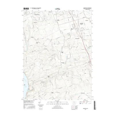
2016 Map of Conestoga
USGS Topo · Published 2016About this map
Martic Forge and Burnt Mills anchor this part of Lancaster County, where the industrial legacy of the region meets the winding paths of the Conestoga River and Pequea Creek. The landscape is a network of small, established settlements like Marticville, Colemanville, and Rawlinsville, each connected by a dense web of township roads and lanes. The map captures the meeting of these inland waterways with the Susquehanna River at Lake Aldred, where the village of Pequea sits near the riverbank. This area preserves a high concentration of local history markers, from the Mount Zion Cem near the town of Conestoga to the Mount Nebo Cem further south. The naming of features like Silver Mine Run and Climbers Run points to a long history of resource extraction and local geography that has shaped the community's layout over generations.
Find a feature on this map
193 named features on this map. Tap any name to fly to it.
Don’t see what you’re looking for? This feature index may not catch every label — zoom into the map to look around manually.
Map Details
Editions of this 2016 Conestoga Map
This is the sole edition of this map. No revisions or reprints were ever made.
Other maps of this area

1902 · Lancaster
USGS Topo · 1:62,500

1904 · Lancaster
USGS Topo · 1:62,500

1906 · New Holland
USGS Topo · 1:62,500

1908 · New Holland
USGS Topo · 1:62,500

1912 · Quarryville
USGS Topo · 1:62,500

1912 · Mc Calls Ferry
USGS Topo · 1:62,500

1941 · New Holland
USGS Topo · 1:62,500

1943 · Lancaster
USGS Topo · 1:62,500

1943 · Quarryville
USGS Topo · 1:62,500

1943 · Mc Calls Ferry
USGS Topo · 1:62,500
Featured Places
- West Lampeter Township, PA
- Willow Street, West Lampeter Township
- Millersville, PA
- Pequea, Conestoga Township
- Conestoga Township, PA