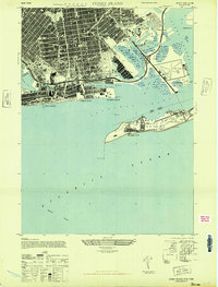
1947 Map of Coney Island
USGS Topo · Published 1947About this map
Coney Island and the southern reaches of Brooklyn are depicted here during the immediate post-war period, showcasing a dense urban grid meeting the complex waterways of Jamaica Bay. The landscape is a study in transition, where the leisure-oriented Boardwalk and Steeplechase at Brighton Beach contrast with the strategic aviation infrastructure at Floyd Bennett Airport. To the east, the marshy terrain of Richs Meadows and Willets Hassock surrounds Barren Island, while the deep waters of Ambrose Channel guide ships toward the harbor. The residential expansion of the era is evident in the numerous schools and hospitals, such as The James Madison High School and Coney Island Hospital. Across the Rockaway Inlet, the U S Military Reservation and Fort Tilden stand watch on Rockaway Point, illustrating the area's dual role as a metropolitan recreational escape and a fortified coastal defensive position.
Find a feature on this map
47 named features on this map. Tap any name to fly to it.
Don’t see what you’re looking for? This feature index may not catch every label — zoom into the map to look around manually.
Map Details
Editions of this 1947 Coney Island Map
This is the sole edition of this map. No revisions or reprints were ever made.
Other maps of this area

1888 · Sandy Hook
USGS Topo · 1:62,500

1889 · Brooklyn
USGS Topo · 1:62,500

1891 · Brooklyn
USGS Topo · 1:62,500

1893 · Sandy Hook
USGS Topo · 1:62,500

1897 · Brooklyn
USGS Topo · 1:62,500

1898 · Staten Island
USGS Topo · 1:62,500

1898 · Brooklyn
USGS Topo · 1:62,500

1900 · Passaic
USGS Topo · 1:125,000

1900 · Staten Island
USGS Topo · 1:62,500

1900 · Brooklyn
USGS Topo · 1:62,500