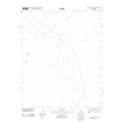
2012 Map of Confidence Hills East
USGS Topo · Published 2012About this map
Confidence Mill sits at the heart of this desert landscape, where the ephemeral drainage of the Amargosa River cuts through the arid valley floor. Located within the southern reaches of Death Valley National Park, the area is defined by complex alluvial patterns including Rhodes Wash and Confidence Wash. The terrain rises sharply to the west into Granite Canyon and Through Canyon, illustrating the stark elevation changes characteristic of this region. Human infrastructure is minimal, centered primarily on the path of Badwater Rd as it skirts the eastern edge of the riverbed. This survey captures the intersection of industrial mining history and modern conservation, showing how historical sites like the mill remain integrated into the protected desert environment.
Find a feature on this map
8 named features on this map. Tap any name to fly to it.
Don’t see what you’re looking for? This feature index may not catch every label — zoom into the map to look around manually.
Map Details
Editions of this 2012 Confidence Hills East Map
This is the sole edition of this map. No revisions or reprints were ever made.
Other maps of this area

1933 · Avawatz Mountains
USGS Topo · 1:250,000

1947 · Trona
USGS Topo · 1:250,000

1948 · Trona
USGS Topo · 1:250,000

1948 · Leach Lake
USGS Topo · 1:62,500

1948 · Avawatz Pass
USGS Topo · 1:62,500

1950 · Confidence Hills
USGS Topo · 1:62,500

1951 · Avawatz Pass
USGS Topo · 1:62,500
1951 · Leach Lake
USGS Topo · 1:62,500

1951 · Shoshone
USGS Topo · 1:62,500

1953 · Trona
USGS Topo · 1:250,000