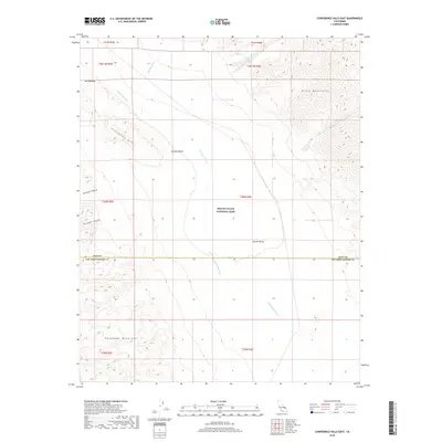
2018 Map of Confidence Hills East
USGS Topo · Published 2018About this map
Death Valley National Park occupies much of this desert landscape, where the ephemeral Amargosa River flows southward through the arid basin. This terminal drainage system is the central topographical feature of the valley floor, flanked by the steep rising slopes of the Black Mountains to the east and the Confidence Hills to the west. The map illustrates a harsh environment shaped by water and wind, from the dramatic constriction of The Narrows to the alluvial fans spreading out from Granite Canyon and Through Canyon. The transition from the Mojave Desert into the southern reaches of the Death Valley floor is marked by significant elevation changes, with drainage paths like Rhodes Wash and Confidence Wash carving into the terrain. The border between Inyo and San Bernardino counties bisects the southern portion of the quadrangle, cutting across the salt-encrusted riverbed.
Find a feature on this map
21 named features on this map. Tap any name to fly to it.
Don’t see what you’re looking for? This feature index may not catch every label — zoom into the map to look around manually.
Map Details
Editions of this 2018 Confidence Hills East Map
This is the sole edition of this map. No revisions or reprints were ever made.
Other maps of this area

1933 · Avawatz Mountains
USGS Topo · 1:250,000

1947 · Trona
USGS Topo · 1:250,000

1948 · Trona
USGS Topo · 1:250,000

1948 · Leach Lake
USGS Topo · 1:62,500

1948 · Avawatz Pass
USGS Topo · 1:62,500

1950 · Confidence Hills
USGS Topo · 1:62,500

1951 · Avawatz Pass
USGS Topo · 1:62,500
1951 · Leach Lake
USGS Topo · 1:62,500

1951 · Shoshone
USGS Topo · 1:62,500

1953 · Trona
USGS Topo · 1:250,000