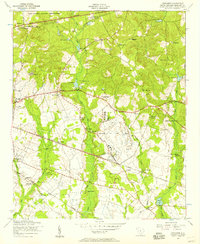
1953 Map of Congaree
USGS Topo · Published 1957About this map
Congaree Air Force Base and the Fort Jackson Military Reservation dominate the central and northern reaches of this Richland County landscape, reflecting the significant mid-century military presence in the region. The map captures a transition from traditional rural South Carolina life to a more mechanized era, as the Atlantic Coast Line and Southern railroads intersect the countryside. Dozens of country churches and community schools are documented here, such as the Zion Benevolent Church, Daughter of Saint Mathews Church, and Siloam School, which served as vital anchors for the dispersed local population. In the northwest, Horrel Hill rises above the terrain, while numerous family-named landmarks like Doc Youngs Pond and Goodin Cemetery provide specific geographic points for genealogists and local historians to trace early 1950s land ownership and community development.
Find a feature on this map
53 named features on this map. Tap any name to fly to it.
Don’t see what you’re looking for? This feature index may not catch every label — zoom into the map to look around manually.
Map Details
Editions of this 1953 Congaree Map
This is the sole edition of this map. No revisions or reprints were ever made.
Other maps of this area

1935 · Killian
USGS Topo · 1:48,000

1937 · Killian
USGS Topo · 1:62,500

1938 · Hagood
USGS Topo · 1:62,500

1941 · Spartanburg
USGS Topo · 1:250,000

1942 · Camden
USGS Topo · 1:125,000

1943 · Eastover
USGS Topo · 1:62,500

1948 · Hopkins
USGS Topo · 1:62,500

1953 · Messers Pond
USGS Topo · 1:24,000

1953 · Saylors Lake
USGS Topo · 1:24,000

1953 · Fort Jackson South
USGS Topo · 1:24,000