
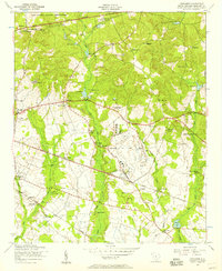
1953 Map of Saylors Lake
USGS Topo · Published 1957About this map
Congaree River meanders through the heart of this mid-century landscape, defining the winding boundary between Richland and Calhoun counties. The terrain transitions from the low-lying, water-dense environments of Mullers Swamp and Roundabout Lake in the north to the rising elevations around Red Hill in the south. This area is heavily marked by rural community centers, particularly churches and family cemeteries, suggesting a stable, long-settled agrarian population. Sandy Run Church and Mount Zion Church serve as central landmarks alongside several dedicated burial grounds such as Kaigler Cemetery and Mount Moriah Cemetery. Of archaeological interest is the Green Hill Mound, situated near the riverbanks, pointing to ancient land use in a region also defined by more recent developments like Saylors Lake and the network of streams including Mill Creek and Sandy Run.
Find a feature on this map
38 named features on this map. Tap any name to fly to it.
Don’t see what you’re looking for? This feature index may not catch every label — zoom into the map to look around manually.
Map Details
Editions of this 1953 Saylors Lake Map
This is the sole edition of this map. No revisions or reprints were ever made.
Other maps of this area

1944 · Edmund
USGS Topo · 1:62,500

1946 · Woodford
USGS Topo · 1:62,500

1946 · St. Matthews
USGS Topo · 1:62,500

1948 · Hopkins
USGS Topo · 1:62,500

1953 · Fort Jackson South
USGS Topo · 1:24,000
1953 · Congaree
USGS Topo · 1:24,000

1953 · Gadsden
USGS Topo · 1:24,000

1954 · Augusta
USGS Topo · 1:250,000

1957 · Augusta
USGS Topo · 1:250,000

1958 · Augusta
USGS Topo · 1:250,000