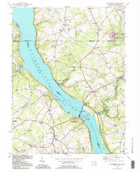
1992 Map of Conowingo Dam
USGS Topo · Published 1995About this map
The Conowingo Dam and its massive Conowingo Reservoir dominate this landscape where the Susquehanna River cuts through the borderlands of Maryland and Pennsylvania. This 1990s revision reveals the intricate topography of the river valley, anchored by the Mason and Dixon Line which divides the map between Lancaster and Cecil counties. The area is dotted with small rural settlements and religious sites, such as St Patricks Ch and Bethesda Cem, reflecting a long-standing community structure that persists alongside the heavy industrial footprint of the Power Plant. Local history is preserved in the names of old crossroads like Kilby Corner and Jenkins Corner, while the surrounding Susquehanna State Park and Emma Rockey Co Park show the preservation of the river's banks. The map also captures specialized infrastructure like the Conowingo Airport and the defunct Conowingo Sta, illustrating the evolution of local transportation and energy production.
Find a feature on this map
75 named features on this map. Tap any name to fly to it.
Don’t see what you’re looking for? This feature index may not catch every label — zoom into the map to look around manually.
Map Details
Editions of this 1992 Conowingo Dam Map
This is the sole edition of this map. No revisions or reprints were ever made.
Other maps of this area

1900 · Havre De Grace
USGS Topo · 1:62,500

1901 · Belair
USGS Topo · 1:62,500

1912 · Quarryville
USGS Topo · 1:62,500

1912 · Mc Calls Ferry
USGS Topo · 1:62,500

1942 · Havre De Grace
USGS Topo · 1:62,500

1942 · Bel Air
USGS Topo · 1:62,500

1943 · Quarryville
USGS Topo · 1:62,500

1943 · Mc Calls Ferry
USGS Topo · 1:62,500

1945 · Bel Air
USGS Topo · 1:62,500

1948 · Baltimore
USGS Topo · 1:250,000
Featured Places
- Little Britain Township, PA
- Poplar Grove, MD
- West Nottingham Township, PA
- Peach Bottom Township, PA
- Jenkins Corner, Fulton Township