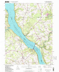
1995 Map of Conowingo Dam
USGS Topo · Published 1999About this map
The Susquehanna River Conowingo Reservoir dominates this landscape, its waters held by the massive Conowingo Dam and its adjacent Power Plant. This 1990s record of the borderlands between Maryland and Pennsylvania shows the river's transformation from a natural waterway into a managed energy source, punctuated by islands like Rowland Island and Sterret Island. Along the northern edge, the historical Mason and Dixon Line divides the map, separating Harford and Cecil Counties from Lancaster, York, and Chester Counties.
Find a feature on this map
73 named features on this map. Tap any name to fly to it.
Don’t see what you’re looking for? This feature index may not catch every label — zoom into the map to look around manually.
Map Details
Editions of this 1995 Conowingo Dam Map
This is the sole edition of this map. No revisions or reprints were ever made.
Other maps of this area

1900 · Havre De Grace
USGS Topo · 1:62,500

1901 · Belair
USGS Topo · 1:62,500

1912 · Quarryville
USGS Topo · 1:62,500

1912 · Mc Calls Ferry
USGS Topo · 1:62,500

1942 · Havre De Grace
USGS Topo · 1:62,500

1942 · Bel Air
USGS Topo · 1:62,500

1943 · Quarryville
USGS Topo · 1:62,500

1943 · Mc Calls Ferry
USGS Topo · 1:62,500

1945 · Bel Air
USGS Topo · 1:62,500

1948 · Baltimore
USGS Topo · 1:250,000
Featured Places
- Little Britain Township, PA
- Poplar Grove, MD
- West Nottingham Township, PA
- Peach Bottom Township, PA
- Jenkins Corner, Fulton Township