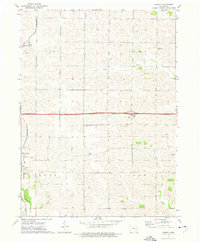
1973 Map of Conroy
USGS Topo · Published 1975About this map
Williamsburg and Conroy anchor this 1970s landscape, illustrating the agricultural and transport patterns of central Iowa. The area is defined by a dense concentration of rural landmarks, particularly in the townships of Hilton, Iowa, Troy, and York. The map shows a clear division between the rail-based infrastructure of the Chicago Milwaukee St Paul and Pacific railroad and the emerging high-speed roadway marked as 4 Lane. This transition era is captured through the numerous country churches and cemeteries, such as St Johns Ch and Pleasant Ridge Cem, which served the farming communities dispersed along Clear Creek, Conroy Creek, and Old Mans Creek. The topographical detail reveals the subtle drainage patterns that dictated early settlement and field placement across the rolling Iowa County terrain.
Find a feature on this map
24 named features on this map. Tap any name to fly to it.
Don’t see what you’re looking for? This feature index may not catch every label — zoom into the map to look around manually.
Map Details
Editions of this 1973 Conroy Map
This is the sole edition of this map. No revisions or reprints were ever made.
Other maps of this area

1888 · Amana
USGS Topo · 1:62,500

1889 · Amana
USGS Topo · 1:62,500

1891 · Oxford
USGS Topo · 1:62,500

1894 · Oxford
USGS Topo · 1:62,500

1899 · Amana
USGS Topo · 1:62,500

1903 · Fairfax
USGS Topo · 1:125,000

1954 · Des Moines
USGS Topo · 1:250,000

1956 · Des Moines
USGS Topo · 1:250,000

1957 · Des Moines
USGS Topo · 1:250,000

1958 · Davenport
USGS Topo · 1:250,000