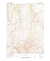
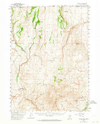
1957 Map of Contact
USGS Topo · Published 1964About this map
Contact sits at the edge of the Bad Lands in northeastern Elko County, serving as a focal point for ranching and mining operations in the late 1950s. The settlement is anchored by the Contact School and surrounded by numerous signs of industrial activity, including shafts and tunnels at the Marshall Mine. This landscape is defined by the canyon-cut terrain of Bonanza Canyon and Blue Jay Gulch, where the headwaters of the North Fork Salmon Falls Creek and Cottonwood Creek drain toward the north. High-elevation ranching is evident at Browns Bench Ranch and Twin Meadows Ranch, which rely on the numerous scattered springs found throughout the Humboldt National Forest and surrounding ridges. The prevalence of Jeep Trails underscores the isolated nature of the mining and grazing claims established across landmarks like L & D Mtn and Bear Mtn.
Find a feature on this map
33 named features on this map. Tap any name to fly to it.
Don’t see what you’re looking for? This feature index may not catch every label — zoom into the map to look around manually.
Map Details
Editions of this 1957 Contact Map
3 editions found
Other maps of this area

1955 · Twin Falls
USGS Topo · 1:250,000

1955 · Wells
USGS Topo · 1:250,000

1957 · Contact
USGS Topo · 1:62,500

1957 · Delaplain
USGS Topo · 1:62,500

1957 · Elk Mountain
USGS Topo · 1:62,500

1958 · Wells
USGS Topo · 1:250,000

1958 · Twin Falls
USGS Topo · 1:250,000

1961 · Wells
USGS Topo · 1:250,000

1968 · Hubbard Basin
USGS Topo · 1:24,000

1968 · Henry
USGS Topo · 1:24,000