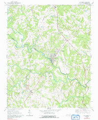
1969 Map of Cooleemee
USGS Topo · Published 1992About this map
The Yadkin River and South Yadkin River converge in this detailed survey of the borderlands between Davie and Rowan counties. The settlement of Cooleemee serves as a central hub, flanked by its namesake railway connection at Cooleemee Junction and the community of North Cooleemee. The landscape is defined by the Southern railroad line and a high concentration of rural landmarks, particularly country churches like St Andrews Ch, Erwin Temple, and Hardison Ch, which reflect the area's deep-rooted community structure.
Find a feature on this map
39 named features on this map. Tap any name to fly to it.
Don’t see what you’re looking for? This feature index may not catch every label — zoom into the map to look around manually.
Map Details
Editions of this 1969 Cooleemee Map
2 editions found
Other maps of this area

1893 · Statesville
USGS Topo · 1:125,000

1950 · Churchland
USGS Topo · 1:24,000

1951 · Churchland
USGS Topo · 1:24,000

1953 · Charlotte
USGS Topo · 1:250,000

1954 · Charlotte
USGS Topo · 1:250,000

1960 · Charlotte
USGS Topo · 1:250,000

1962 · Charlotte
USGS Topo · 1:250,000
1962 · Salisbury
USGS Topo · 1:24,000

1969 · Cooleemee
USGS Topo · 1:24,000

1969 · Cool Springs
USGS Topo · 1:24,000