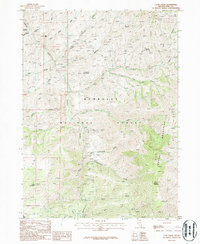
1986 Map of Coon Creek
USGS Topo · Published 1987About this map
Humboldt National Forest dominates this section of Elko County, Nevada, where the High Desert landscape is defined by the headwaters of the Bruneau River and a series of prominent peaks. This mid-1980s provisional survey illustrates a complex drainage system including Coon Creek, American Creek, and Cottonwood Creek, which have carved deep features like Marcellini Canyon and Wickiup Gulch. The terrain is punctuated by significant elevations such as Granite Mountain, Pine Mountain, and the Copper Mountains, the latter featuring Copper Mountain itself.
Find a feature on this map
29 named features on this map. Tap any name to fly to it.
Don’t see what you’re looking for? This feature index may not catch every label — zoom into the map to look around manually.
Map Details
Editions of this 1986 Coon Creek Map
This is the sole edition of this map. No revisions or reprints were ever made.
Other maps of this area

1935 · Charleston
USGS Topo · 1:48,000

1936 · Rowland
USGS Topo · 1:48,000

1940 · Rowland
USGS Topo · 1:62,500

1942 · Mt. Velma
USGS Topo · 1:62,500

1943 · Jarbidge
USGS Topo · 1:62,500

1945 · Jarbidge
USGS Topo · 1:62,500

1955 · Wells
USGS Topo · 1:250,000

1958 · Wells
USGS Topo · 1:250,000

1961 · Wells
USGS Topo · 1:250,000
1968 · Marys River Basin NW
USGS Topo · 1:24,000