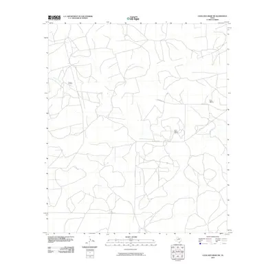
2010 Map of Coon Dive Draw NW
USGS Topo · Published 2010About this map
Sterling Creek meanders through this section of Sterling County, defining a landscape marked by the infrastructure of West Texas ranching. The presence of the Edwards Cemetery near the creek's upper reaches offers a specific point of interest for genealogists tracing local family histories in this rural area. Away from the water, the terrain is dotted with functional landmarks essential for livestock management, such as the Wilson Pasture Windmill and the Bull Pasture Windmill. The network of local roads, including Old Big Lake Rd and Brownfield Rd, connects these remote pastures to regional routes like FM 2139, illustrating the sparse but deliberate layout of land use in the early 21st century.
Find a feature on this map
7 named features on this map. Tap any name to fly to it.
Don’t see what you’re looking for? This feature index may not catch every label — zoom into the map to look around manually.
Map Details
Editions of this 2010 Coon Dive Draw NW Map
This is the sole edition of this map. No revisions or reprints were ever made.
Other maps of this area

1954 · San Angelo
USGS Topo · 1:250,000

1958 · San Angelo
USGS Topo · 1:250,000

1963 · Cumbie Draw
USGS Topo · 1:24,000

1963 · Glass Ranch
USGS Topo · 1:24,000

1963 · Currie Reservoir
USGS Topo · 1:24,000

1965 · San Angelo
USGS Topo · 1:250,000

1973 · Hay Hollow
USGS Topo · 1:24,000

1973 · Three Bluff Draw
USGS Topo · 1:24,000
1973 · Coon Dive Draw
USGS Topo · 1:24,000

1973 · Three Bluff Draw NE
USGS Topo · 1:24,000