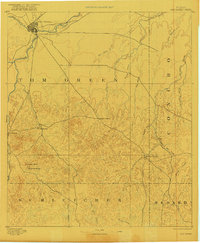
1954 Map of San Angelo
USGS Topo · Published 1967About this map
San Angelo serves as the regional anchor for the Concho Valley in the mid-1960s, situated at the confluence of the North Concho River, South Concho River, and Middle Concho River. The landscape is defined by the significant hydrological developments of the era, notably the San Angelo Res and the newly appearing Twin Buttes Res, which transformed the local water management and recreation. To the southeast, Goodfellow AFB marks the city's military importance. Moving west across the Edwards Plateau, the map traces the arid draws like Mustang Draw and Centralia Draw towards the oil-rich regions near Big Lake and Santa Rita. The presence of numerous windmills across Glasscock County and Reagan County illustrates the reliance on groundwater for the ranching economy that persists alongside the burgeoning petroleum industry in the Permian Basin's eastern edge.
Find a feature on this map
85 named features on this map. Tap any name to fly to it.
Don’t see what you’re looking for? This feature index may not catch every label — zoom into the map to look around manually.
Map Details
Editions of this 1954 San Angelo Map
2 editions found
Historical Maps of San Angelo Through Time
5 maps found