
Loading...
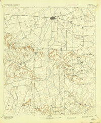
Loading map...1890 Map of Abilene
USGS Topo · Published 1955About this map
Abilene sits at the northern edge of this West Texas survey, defined by the essential corridor of the Texas and Pacific Railway. The rail line, accompanied by settlements like Elmdale, provides a stark contrast to the dramatic topography of the Callahan Divide to the south. This transition from the flat rail prairies into a complex series of mesas and gaps was central to the region's early cattle and transport routes.
Find a feature on this map
39 named features on this map. Tap any name to fly to it.
Don’t see what you’re looking for? This feature index may not catch every label — zoom into the map to look around manually.
Map Details
Date Portrayed1890
Date Published1955
PublisherU.S. Geological Survey
Map TypeTopographic
Scale1:125,000
Physical Dimensions17 x 20.8 inches
Editions of this 1890 Abilene Map
This is the sole edition of this map. No revisions or reprints were ever made.
Historical Maps of Abilene Through Time
5 maps found

Featured Locations
Source Details
SourceU.S. Geological Survey
CopyrightPublic Domain