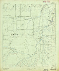
1891 Map of Anson
USGS Topo · Published 1891About this map
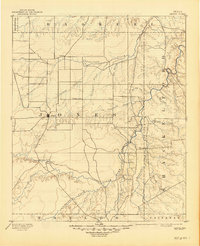
Anson stands as a central hub in this late nineteenth-century survey, surrounded by a frontier landscape defined by its complex drainage systems. The Clear Fork of Brazos River snakes through the eastern half of the region, where family-named landmarks and early outposts like Phantom Hill and Rising Sun indicate the slow expansion of Jones County. The geography is dominated by numerous intermittent waterways such as California Creek, Redmud Creek, and Deadman Creek, which dictated the location of small, isolated settlements. These early communities, including Sandersville, Lenoir, and Newsom, reflect a period before the arrival of major rail lines, when the local economy was tied directly to the land and the proximity of seasonal water sources. The map provides a distinct view of the transition from open range to established township as the frontier began to settle into a more permanent agricultural pattern.
Find a feature on this map
31 named features on this map. Tap any name to fly to it.
Don’t see what you’re looking for? This feature index may not catch every label — zoom into the map to look around manually.
Map Details
Editions of this 1891 Anson Map
This is the sole edition of this map. No revisions or reprints were ever made.
Historical Maps of Abilene Through Time
8 maps found