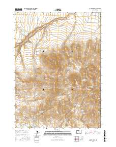
2017 Map of Cooper Draw
USGS Topo · Published 2017About this map
Coyote Hills dominates the central landscape of this Lake County region, where a complex network of draws and springs defines the high-desert hydrology. The map reveals a systematic approach to water management through features like General Reservoir, Spring Reservoir, and Upper Juniper Reservoir, which suggest the area's importance for livestock or seasonal water storage. Drainage patterns are clearly marked by Rabbit Cr in the north and Snyder Cr to the south, while numerous named water sources such as Oregon Spring and Pipe Spring dot the terrain. For the researcher, the map preserves specific local nomenclature for the land's folds, including Mary Ann Draw and Windy Hollow Draw, providing a precise record of how this remote basin was navigated and utilized in the early twenty-first century.
Find a feature on this map
26 named features on this map. Tap any name to fly to it.
Don’t see what you’re looking for? This feature index may not catch every label — zoom into the map to look around manually.
Map Details
Editions of this 2017 Cooper Draw Map
This is the sole edition of this map. No revisions or reprints were ever made.
Other maps of this area

1955 · Klamath Falls
USGS Topo · 1:250,000

1955 · Adel
USGS Topo · 1:250,000

1957 · Adel
USGS Topo · 1:250,000

1958 · Klamath Falls
USGS Topo · 1:250,000

1958 · Adel
USGS Topo · 1:250,000

1962 · Adel
USGS Topo · 1:250,000

1966 · Rabbit Hills NW
USGS Topo · 1:24,000

1967 · Plush
USGS Topo · 1:24,000

1967 · Rabbit Hills SW
USGS Topo · 1:24,000
1968 · Drake Peak NE
USGS Topo · 1:24,000