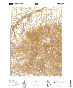
2020 Map of Cooper Draw
USGS Topo · Published 2020About this map
Coyote Hills rise prominently in this high-desert landscape of Lake County, where water management defines the human footprint. The map reveals a network of natural springs and man-made impoundments essential for life in this arid region, including General Reservoir, Spring Reservoir, and the Upper Juniper Reservoir. These features, alongside named points like Oregon Spring and Ellie Spring, suggest a history of ranching and livestock grazing that continues to shape the local geography.
Find a feature on this map
26 named features on this map. Tap any name to fly to it.
Don’t see what you’re looking for? This feature index may not catch every label — zoom into the map to look around manually.
Map Details
Editions of this 2020 Cooper Draw Map
This is the sole edition of this map. No revisions or reprints were ever made.
Other maps of this area

1955 · Klamath Falls
USGS Topo · 1:250,000

1955 · Adel
USGS Topo · 1:250,000

1957 · Adel
USGS Topo · 1:250,000

1958 · Klamath Falls
USGS Topo · 1:250,000

1958 · Adel
USGS Topo · 1:250,000

1962 · Adel
USGS Topo · 1:250,000

1966 · Rabbit Hills NW
USGS Topo · 1:24,000

1967 · Plush
USGS Topo · 1:24,000

1967 · Rabbit Hills SW
USGS Topo · 1:24,000
1968 · Drake Peak NE
USGS Topo · 1:24,000