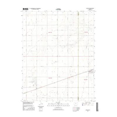
2016 Map of Copeland
USGS Topo · Published 2016About this map
The high plains of southwest Kansas are defined here by the agricultural grid and the gentle meandering of Crooked Cr through Gray and Haskell counties. The town of Copeland serves as the primary hub of the region, situated along a prominent rail line and highway corridor that connects local farms to wider markets. Within the town limits, specific street names like Mcbride St and Thatcher St provide a detailed framework for local property research, while the local Po marks the civic center. Further west, the settlement of Tice sits along the same transportation spine, surrounded by an expansive network of county roads including Co Rd 160 and Co Rd UU. This landscape reflects the enduring rural economy of the mid-2010s, where traditional section lines dictate the movement of commerce and the placement of remote homesteads.
Find a feature on this map
36 named features on this map. Tap any name to fly to it.
Don’t see what you’re looking for? This feature index may not catch every label — zoom into the map to look around manually.
Map Details
Editions of this 2016 Copeland Map
This is the sole edition of this map. No revisions or reprints were ever made.
Other maps of this area

1896 · Garden
USGS Topo · 1:125,000

1955 · Dodge City
USGS Topo · 1:250,000

1958 · Dodge City
USGS Topo · 1:250,000

1959 · Dodge City
USGS Topo · 1:250,000

1959 · Garden City 3 NE
USGS Topo · 1:24,000

1960 · Garden City 3 SE
USGS Topo · 1:24,000

1967 · Plains NE
USGS Topo · 1:24,000

1968 · Plains NW
USGS Topo · 1:24,000
1968 · Sublette
USGS Topo · 1:24,000
1969 · Copeland SE
USGS Topo · 1:24,000