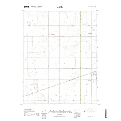
2018 Map of Copeland
USGS Topo · Published 2018About this map
Copeland serves as the primary hub in this portion of southwest Kansas, situated along the border of Haskell Co and Gray Co. The landscape is defined by the high plains' characteristic grid system of section roads, including long-stretching routes like Co Rd 160 and Co Rd VV, which facilitate the region's agricultural movement. The intermittent flow of Crooked Cr winds through the northeast, providing the most significant natural break in the otherwise meticulously surveyed terrain. Near the western edge of the map, the small settlement of Tice stands as a distinct waypoint along the rail corridor. The precision of the 2018 survey captures the transition between the rural townships of t28s r31w and t29s r30w, illustrating how local thoroughfares such as Tice St and Mcbride St link these isolated prairie communities to the broader state transport network.
Find a feature on this map
34 named features on this map. Tap any name to fly to it.
Don’t see what you’re looking for? This feature index may not catch every label — zoom into the map to look around manually.
Map Details
Editions of this 2018 Copeland Map
This is the sole edition of this map. No revisions or reprints were ever made.
Other maps of this area

1896 · Garden
USGS Topo · 1:125,000

1955 · Dodge City
USGS Topo · 1:250,000

1958 · Dodge City
USGS Topo · 1:250,000

1959 · Dodge City
USGS Topo · 1:250,000

1959 · Garden City 3 NE
USGS Topo · 1:24,000

1960 · Garden City 3 SE
USGS Topo · 1:24,000

1967 · Plains NE
USGS Topo · 1:24,000

1968 · Plains NW
USGS Topo · 1:24,000
1968 · Sublette
USGS Topo · 1:24,000
1969 · Copeland SE
USGS Topo · 1:24,000