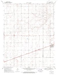
1969 Map of Copeland
USGS Topo · Published 1971About this map
The agricultural landscape of southwestern Kansas is defined by the straight path of the Atchison Topeka and Santa Fe railroad, which cuts diagonally across the prairie in the late 1960s. This transportation corridor connects the small grain-handling settlements of Copeland and Tice, where a dense network of sections and field lines are clearly visible. The terrain is relatively flat, punctuated by the winding course of Crooked Creek in the northeast and a local Cem nearby. The map reveals a highly organized land-use pattern where the county line between Haskell Co and Gray Co is nearly invisible on the ground but critical for administrative and property boundaries. Infrastructure of the era is represented by a prominent Radio Tower and numerous wells scattered throughout the township of Lockport, reflecting the importance of water management and communication in the High Plains.
Find a feature on this map
9 named features on this map. Tap any name to fly to it.
Don’t see what you’re looking for? This feature index may not catch every label — zoom into the map to look around manually.
Map Details
Editions of this 1969 Copeland Map
This is the sole edition of this map. No revisions or reprints were ever made.
Other maps of this area

1896 · Garden
USGS Topo · 1:125,000

1955 · Dodge City
USGS Topo · 1:250,000

1958 · Dodge City
USGS Topo · 1:250,000

1959 · Dodge City
USGS Topo · 1:250,000

1959 · Garden City 3 NE
USGS Topo · 1:24,000

1960 · Garden City 3 SE
USGS Topo · 1:24,000

1967 · Plains NE
USGS Topo · 1:24,000

1968 · Plains NW
USGS Topo · 1:24,000
1968 · Sublette
USGS Topo · 1:24,000
1969 · Copeland SE
USGS Topo · 1:24,000