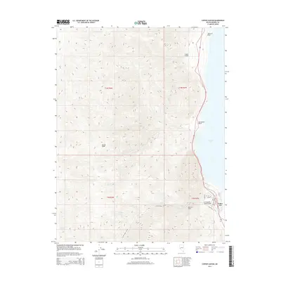
2014 Map of Copper Canyon
USGS Topo · Published 2014About this map
The high desert peaks of the Wassuk Range dominate this landscape, rising sharply from the western shores of Walker Lake. The shoreline is marked by the presence of Sportsmans Beach and Tamarack Point, providing access to the expansive water body. The terrain is deeply incised by steep drainage systems including Copper Canyon, Red Fox Gulch, and the prominent Cottonwood Canyon. Water sources in this arid environment are clustered at the base of the mountains, noted by labels for Sorhouet Springs, Wild Horse Spring, and Chipmunk Spring. While the western portion of the map is defined by topographic elevation and seasonal drainages like Dry Cr and Dutch Cr, the eastern edge reveals a small network of residential streets including Lisa Dr and Debbie near the lakefront.
Find a feature on this map
25 named features on this map. Tap any name to fly to it.
Don’t see what you’re looking for? This feature index may not catch every label — zoom into the map to look around manually.
Map Details
Editions of this 2014 Copper Canyon Map
This is the sole edition of this map. No revisions or reprints were ever made.
Other maps of this area

1909 · Hawthorne
USGS Topo · 1:250,000

1911 · Hawthorne
USGS Topo · 1:250,000

1915 · Hawthorne
USGS Topo · 1:250,000

1948 · Walker Lake
USGS Topo · 1:250,000

1955 · Hawthorne
USGS Topo · 1:62,500

1956 · Mt. Grant
USGS Topo · 1:62,500

1957 · Walker Lake
USGS Topo · 1:250,000

1962 · Walker Lake
USGS Topo · 1:250,000

1964 · Walker Lake
USGS Topo · 1:250,000

1964 · Gillis Canyon
USGS Topo · 1:62,500