
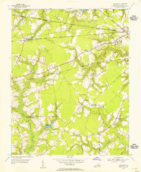
1954 Map of Corapeake
USGS Topo · Published 1955About this map
Cypress Chapel and Corapeake anchor this mid-century look at the borderlands where Virginia meets North Carolina. The landscape is defined by the expansive Dismal Swamp to the east and a series of water-rich features including Cypress Swamp, Moss Swamp, and Taylor Swamp. This environment dictated a settlement pattern follows higher ground and road networks like Dragon Road, leaving large tracts of Pine Swamp and Hall Pocosin relatively undeveloped. Family names and local history are preserved in the numerous small burial grounds and rural houses of worship, such as Brickley Cem, Winslow Cem, and Eureka Ch. The geography reveals how early agriculture and timbering adapted to the low-lying terrain, with features like Jones Millpond and Ure Island highlighting the transition from open water to marshy woodland.
Find a feature on this map
34 named features on this map. Tap any name to fly to it.
Don’t see what you’re looking for? This feature index may not catch every label — zoom into the map to look around manually.
Map Details
Editions of this 1954 Corapeake Map
This is the sole edition of this map. No revisions or reprints were ever made.
Other maps of this area

1906 · Beckford
USGS Topo · 1:48,000

1907 · Beckford
USGS Topo · 1:62,500

1919 · Suffolk
USGS Topo · 1:62,500

1940 · Beckford
USGS Topo · 1:62,500

1940 · Lake Drummond
USGS Topo · 1:62,500

1940 · South Mills
USGS Topo · 1:62,500

1945 · Lake Drummond
USGS Topo · 1:62,500

1952 · South Mills
USGS Topo · 1:62,500

1953 · Norfolk
USGS Topo · 1:250,000
1954 · Buckhorn
USGS Topo · 1:24,000