
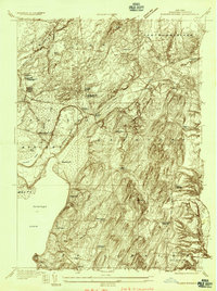
1935 Map of Corinth
USGS Topo · Published 1935About this map
The Hudson River defines the northern reaches of this Saratoga County landscape, where the village of Corinth and neighboring Palmer serve as focal points for local industry and transport. The Delaware and Hudson RR tracks follow the river's path, supporting the Spier Falls Hydro Sta and the surrounding mill towns. This 1935 survey captures a network of rural schoolhouses, such as Rock Sch and Dist School No 11, which once anchored the dispersed agricultural communities between the upland ridges of Rock Hill and Bailey Hill.
Find a feature on this map
43 named features on this map. Tap any name to fly to it.
Don’t see what you’re looking for? This feature index may not catch every label — zoom into the map to look around manually.
Map Details
Editions of this 1935 Corinth Map
This is the sole edition of this map. No revisions or reprints were ever made.
Other maps of this area

1895 · Glens Falls
USGS Topo · 1:62,500

1897 · Glens Falls
USGS Topo · 1:62,500

1900 · Schuylerville
USGS Topo · 1:62,500

1902 · Saratoga
USGS Topo · 1:62,500

1903 · Luzerne
USGS Topo · 1:62,500
1934 · Quaker Springs
USGS Topo · 1:24,000

1934 · Saratoga Springs
USGS Topo · 1:24,000

1935 · Gansevoort
USGS Topo · 1:24,000

1935 · Middle Grove
USGS Topo · 1:24,000

1938 · Glens Falls
USGS Topo · 1:62,500