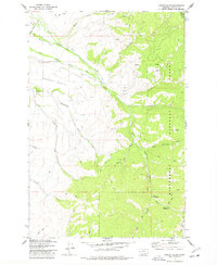
1977 Map of Corley Gulch
USGS Topo · Published 1978About this map
The Bitterroot National Forest dominates the landscape of this 1970s survey, illustrating a rugged interface between high-country wilderness and agricultural valley floor. The Sunset Bench rises as a prominent geographic feature in the west, while the lower reaches of the Bitterroot Irr Dist Canal and Mill Fork indicate the vital importance of water management for the region's ranching and irrigation history.
Find a feature on this map
37 named features on this map. Tap any name to fly to it.
Don’t see what you’re looking for? This feature index may not catch every label — zoom into the map to look around manually.
Map Details
Editions of this 1977 Corley Gulch Map
This is the sole edition of this map. No revisions or reprints were ever made.
Other maps of this area

1901 · Hamilton
USGS Topo · 1:125,000

1903 · Bonner
USGS Topo · 1:125,000

1909 · Sapphire
USGS Topo · 1:125,000

1912 · Missoula
USGS Topo · 1:125,000

1947 · Butte
USGS Topo · 1:250,000

1956 · Hamilton
USGS Topo · 1:250,000

1958 · Butte
USGS Topo · 1:250,000

1959 · Hamilton
USGS Topo · 1:250,000

1959 · Cleveland Mountain
USGS Topo · 1:62,500

1960 · Butte
USGS Topo · 1:250,000