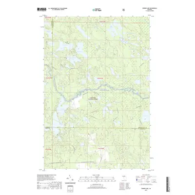
2019 Map of Corner Lake
USGS Topo · Published 2019About this map
The Indian Wild and Scenic River forms a central ribbon through this portion of the Hiawatha National Forest, illustrating a landscape defined by glacial lakes and protected waterways. The map details an extensive network of recreational infrastructure, from the Indian River Canoe Route to specialized paths like the Bil Vance Hiking trail and the Camel Riders snowmobile route. The concentration of water bodies, including Big Island Lake, Petes Lake, and McKeever Lake, suggests a region long utilized for seasonal passage and conservation. Notable terrain features such as Brunos Run and Pine Marten Run cross through various lake basins, marking the complex drainage patterns of the Upper Peninsula. Boundary lines for Alger, Schoolcraft, and Delta counties converge here, highlighting the intersection of local jurisdictions within the federal forest lands.
Find a feature on this map
73 named features on this map. Tap any name to fly to it.
Don’t see what you’re looking for? This feature index may not catch every label — zoom into the map to look around manually.
Map Details
Editions of this 2019 Corner Lake Map
This is the sole edition of this map. No revisions or reprints were ever made.
Other maps of this area

1931 · Steuben SW
USGS Topo · 1:31,680

1931 · Shingleton SW
USGS Topo · 1:31,680

1931 · Steuben NW
USGS Topo · 1:31,680

1931 · Skeels Lake NE
USGS Topo · 1:31,680

1931 · Munising SE
USGS Topo · 1:31,680

1932 · Skeels Lake SE
USGS Topo · 1:31,680

1932 · Skeels Lake NW and SW
USGS Topo · 1:31,680

1958 · Corner Lake
USGS Topo · 1:62,500

1958 · Munising
USGS Topo · 1:62,500

1958 · Shingleton
USGS Topo · 1:62,500