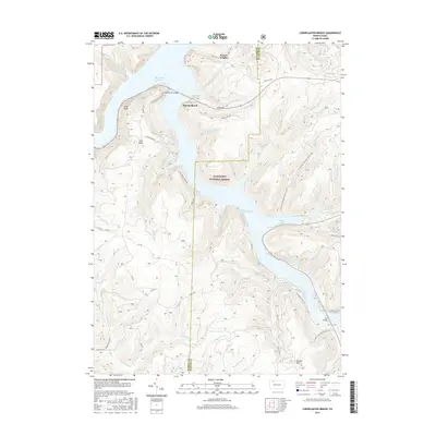
2016 Map of Cornplanter Bridge
USGS Topo · Published 2016About this map
The Allegheny Reservoir dominates this portion of the Allegheny National Forest, where the flooded valleys of the Allegheny River system create a complex shoreline of deep bays and steep ridges. The namesake Cornplanter Bridge serves as a vital crossing point, connecting the western heights near Jakes Rocks to the eastern wilderness. Local settlements and recreation spots like Kinzua Heights and Kinzua Beach are positioned along the upper reaches of the reservoir, while the southern waters reach into Kinzua Bay and Chappel Bay.
Find a feature on this map
51 named features on this map. Tap any name to fly to it.
Don’t see what you’re looking for? This feature index may not catch every label — zoom into the map to look around manually.
Map Details
Editions of this 2016 Cornplanter Bridge Map
This is the sole edition of this map. No revisions or reprints were ever made.
Other maps of this area

1906 · Warren
USGS Topo · 1:62,500

1907 · Warren
USGS Topo · 1:62,500

1908 · Warren
USGS Topo · 1:62,500

1934 · Kane
USGS Topo · 1:48,000

1935 · Sheffield
USGS Topo · 1:48,000

1936 · Kinzua
USGS Topo · 1:48,000

1939 · Kane
USGS Topo · 1:62,500

1941 · Sheffield
USGS Topo · 1:62,500

1941 · Kinzua
USGS Topo · 1:62,500
1949 · Kinzua
USGS Topo · 1:62,500
Featured Places
- Sheffield Township, PA
- Corydon Township, PA
- Glade Township, PA
- Elijah, Hamilton Township
- Mead Township, PA