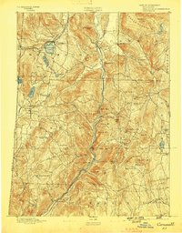
1893 Map of Cornwall
USGS Topo · Published 1898About this map
The Housatonic River carves a deep valley through Litchfield County, serving as the central artery for industry and transport in the late 19th century. Along its banks, the Housatonic Railroad connects several small industrial and agricultural centers, including Falls Village, West Cornwall, and Cornwall Bridge. To the northwest, the New England and Western Railroad passes through Salisbury and Lakeville, where the presence of Wononscopomus Lake and Wononpakook Lake defines the local landscape. The terrain is marked by significant elevations like Canaan Mountain and Mohawk Mountain, while evidence of the region’s mineral history is found at Ore Hill and Mine Mt. This survey provides a look at the rural township structures of Sharon, Cornwall, and Goshen before the modernization of the 20th century.
Find a feature on this map
83 named features on this map. Tap any name to fly to it.
Don’t see what you’re looking for? This feature index may not catch every label — zoom into the map to look around manually.
Map Details
Editions of this 1893 Cornwall Map
3 editions found

Other maps of this area

1885 · Sheffield
USGS Topo · 1:62,500

1888 · Sheffield
USGS Topo · 1:62,500

1888 · Sandisfield
USGS Topo · 1:62,500

1891 · Sheffield
USGS Topo · 1:62,500

1892 · Winsted
USGS Topo · 1:62,500

1892 · Cornwall
USGS Topo · 1:62,500

1892 · New Milford
USGS Topo · 1:62,500

1893 · Waterbury
USGS Topo · 1:62,500

1893 · Sheffield
USGS Topo · 1:62,500

1893 · New Milford
USGS Topo · 1:62,500